While we wait for a crew change, we have got a few days in Rønne, so, we decided to explore the area …. by foot … Well at least by foot once we had caught a bus somewhere! Armed with a four day bus pass we decided to try and find out more about Bornholm. The island is Danish, which in itself is slightly odd as the nearest land in most directions is either Sweden or Germany. Denmark itself is a long way away, so how come it is Danish? It has a mixed history; it was pawned to Lübeck for 50 years starting in 1525. It’s not clear why this was, but it was either one hell of a poker game or the Danish were in financial trouble in some way. It then returned to the Danes only for the Swedes to conquer the islands in 1645. It was then, however, ceded to the Swedes in 1658 as part of the Treaty of Roskilde. The locals though didn’t like this at all and revolted. This culminated in the shooting of the local Swedish commander – Johan Printzensköld. So, following the revolt, a deputation of islanders gave the island as a gift to King Frederick III of Denmark. This was on the condition that the island would never be given up again – something confirmed in the Treaty of Copenhagen in 1660. So, Danish it remains …..
Rønne to Hasle
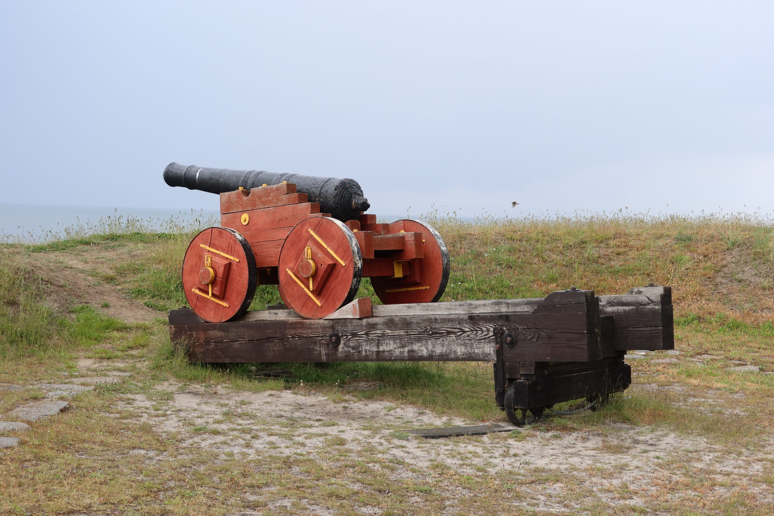
For our first day we walked from the marina up to Hasle. This took us through a beautiful forest area and then along the coast up towards Hasle. The coast took on a new character as we got nearer to the town and the first oddity was a cannon. We stayed fairly well clear as it was apparently aimed at the English – well the English in 1807-14. This period is known as the English Wars in Scandinavia and was a period when England and Sweden were pitted against Denmark and Norway as part of the Napoleonic Wars. The west coast of Bornholm apparently had these cannons at strategic intervals all along the coast.
Just further along from this was the evidence of coal mining. During the 17th and 18th centuries there were various attempts to exploit the coal reserves along the coast, but there wasn’t really much demand for coal on Bornholm so the mines mainly prospered during the English Wars period. A weird eroded section of coast known as Kultippen is all that remains of this industry which then morphed into a tile industry instead – something which is much more in evidence in the area. The local clay was suited to tile manufacture and there was an extensive market for Hasle tiles right across Denmark. Even that industry is now gone and fishing was then the key industry after the harbour was built. This is still very obvious all around with smokehouse chimneys all around the town and surrounding villages. We headed straight for the largest of these and one which is still active – the Hasle Rogerij. We had visited a few years ago and had an excellent fish buffet and we can report that it is still excellent! from there we took the bus back to Rønne.
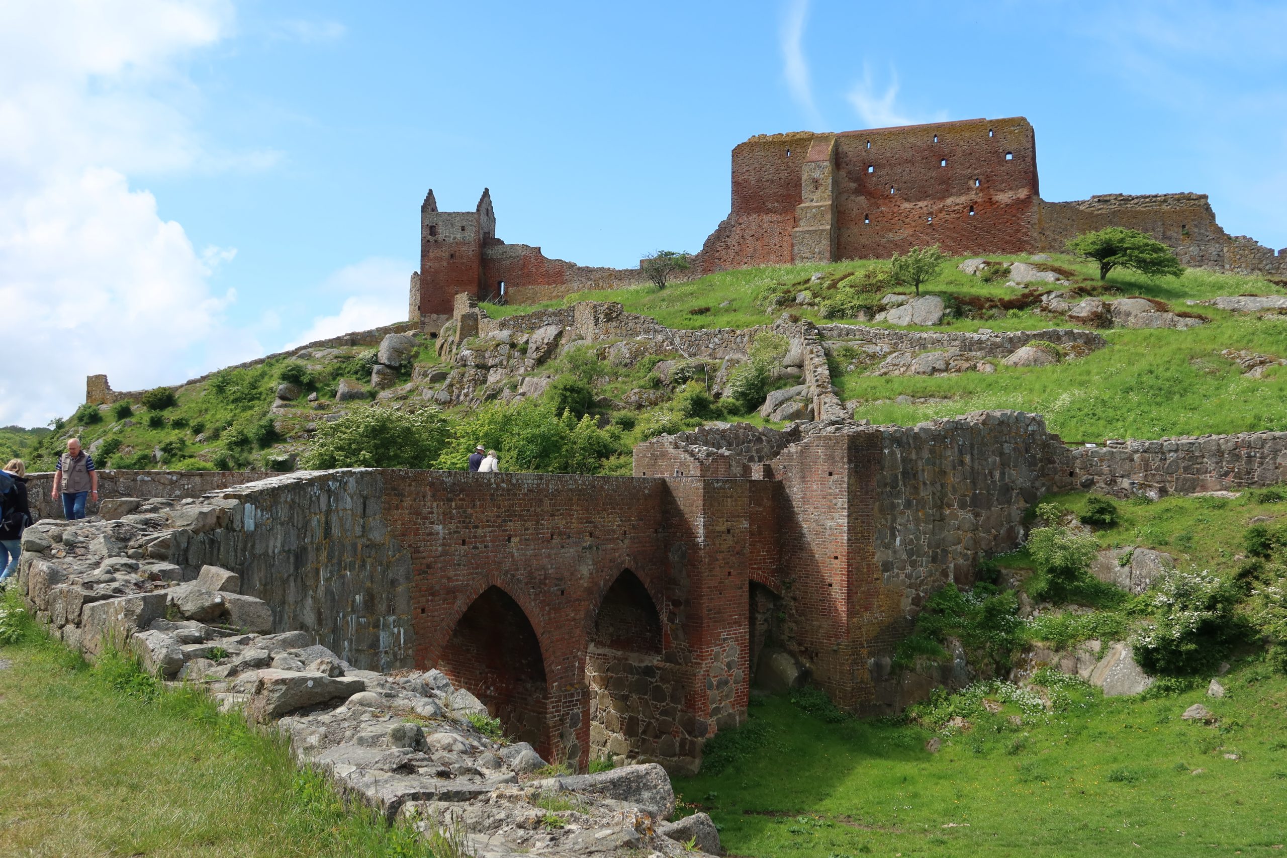
Hammerhus to Hasle
The next day we took the bus right up to the north of the island – Hammerhus. Hammerhus castle is (or was …) the largest medieval fortification in Scandinavia and was a key focus of the various struggles between Lübeck, Sweden and Denmark. Eventually, after the revolt in 1658 it became permanently Danish and the fortress was abandoned in 1743. The remains have been preserved for a long time and there is an ongoing programme of maintenance and restoration. The bus dropped us right by the castle and we headed straight down the coast path towards Vang – a lovely walk enlivened by orchid spotting on the way.
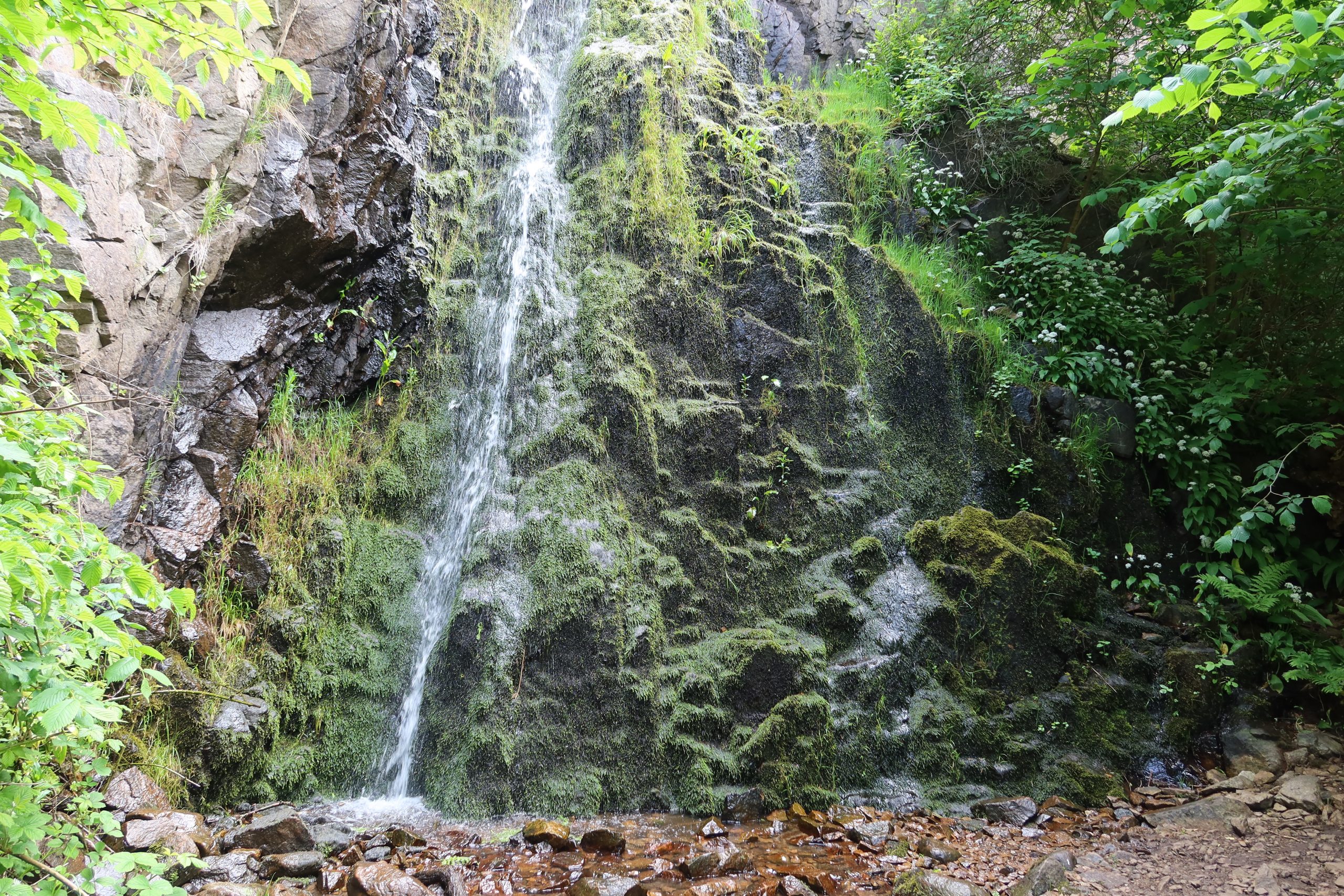
Just before Vang we got to the wonderfully named waterfall – Pissebækken. This literally means pissing stream and it has the dubious honour of being the third highest waterfall in Denmark … dubious because … it isn’t very high! The names is thought to come from the fact that in summer when the flow of the water is quite low, it resembles someone peeing over the edge.
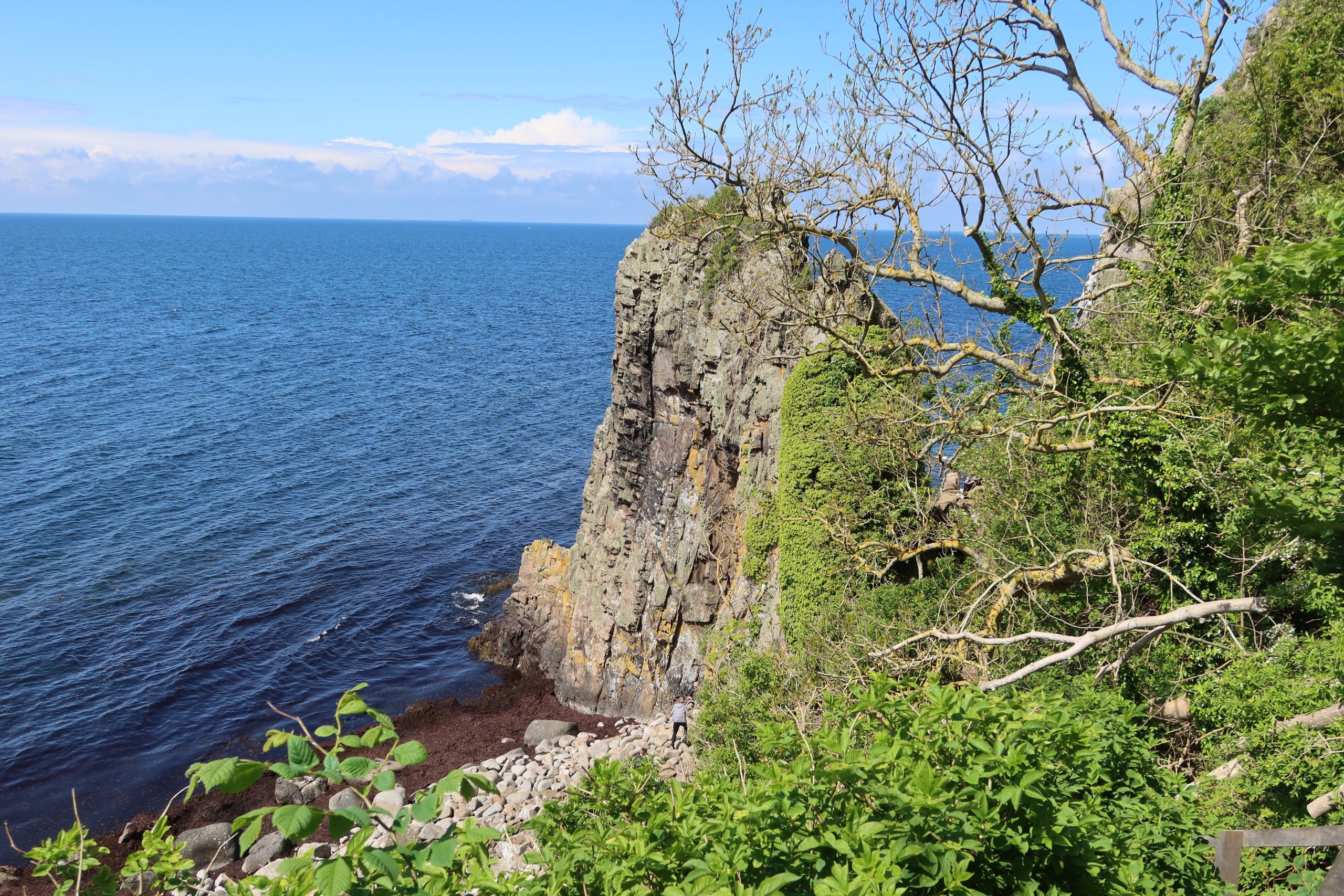
From there we had lunch in Vang and then headed on down the coast towards Hasle taking a slight diversion down 150 steps to Jon’s Chapel. The story goes that Jon was a reclusive missionary (seems like an oxymoron) and that instead of a church to preach in, he used a rock formation that resembled a spire with a small ledge which is now known as the ‘pulpit’. He would then preach to the people on the beach. The caves to the south of this formation are known as Jon’s Food Cellar, Jon’s Sacristy, Jon’s Bedroom and Jon’s Dining Room – a full house in the rock! There is even a giant cauldron (a glacial pothole, sometimes called a Giant’s Kettle) on the beach which was known as Jon’s Baptismal Font. Seems like a bit of a cheapskate missionary if he didn’t even build the church himself …..
From there the path gradually sloped down to sea level with a lovely walk through a couple of old fishing villages – Teglkås and Helligpeder – and finally into Hasle where we got the bus back to Rønne.
Almindingen
For the third day of our four day bus pass we headed into the centre of the island to a national forest park called Almindingen. We followed a path through the forest and then on a boardwalk over a wetland area eventually coming to a large fence and heavy gate. The reason for these was not to keep us out, but to keep the bison in. Yes … bison … In the early 20th century European Bison were hunted virtually to extinction with the last wild animals shot in 1921 on the Belarussian/Polish border region. A small population remained in captivity and this population has been used to gradually try and reintroduce them in various places. One of those places is Bornholm where in 2012 they brought five females and one male from Poland. The male has clearly been busy as the herd is now larger but, while they have decided to keep them on Bornholm, they are keeping them fenced in a large enclosure. The herd apparently attracts around 100,000 visitors a year, though they don’t specify how many of the visitors actually see them as they are quite reclusive animals. We didn’t see them, but perhaps the other 99,998 visitors do!
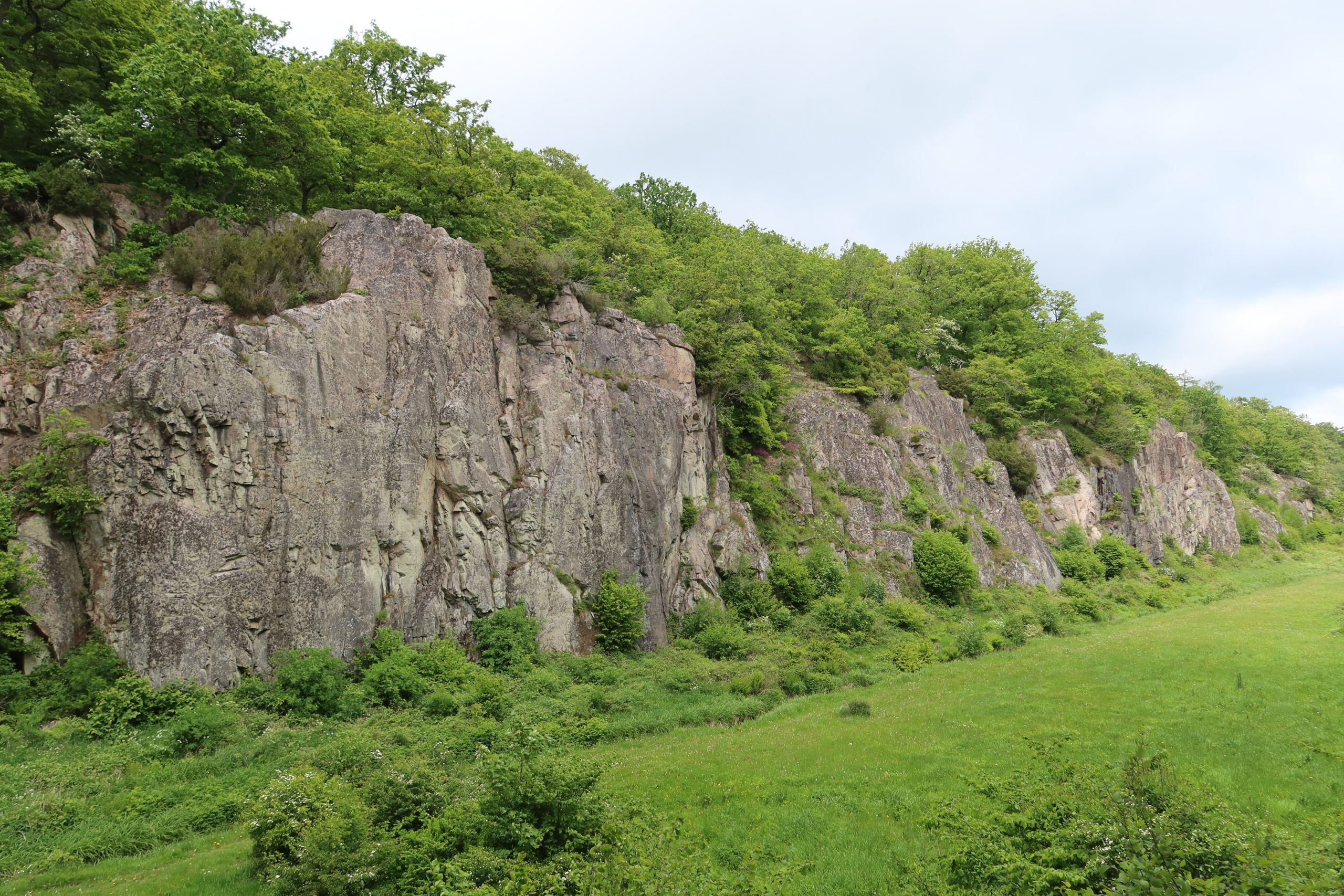
From there we headed across to Ekkodalen – Echo Valley. This is Denmark’s longest rift valley at 12km in length. When it comes to the Guinness Book of Records, not many Danish features are likely to be challenging for the top place! However, it is a beautiful valley and we walked down one side and then up onto the granite cliffs to walk back along the other side. At the end of this section we came across the ruins of Gamleborg. This is a fortress which was built around 750 AD and was the seat of the kings of Bornholm during the Viking age and early Middle Ages. It is quite a size – 264 metres long from north to south and 110 metres wide from east to west and though little remains, it is still an impressive site.